In November 2017 the V&A announced that it had acquired a section of Robin Hood Gardens housing estate in Poplar, East London, ‘a defining example of Brutalist architecture and social housing’ that was in the process of being demolished.1
The proposed demolition of the Robin Hood Gardens estate had been debated for nearly a decade before it finally began in August 2017. While some, including Tower Hamlets Council and many residents of the estate, were keen to see the site redeveloped, others were upset at its threatened demise, and made concerted efforts to save it.2 The V&A’s announcement that it had acquired a tiny section of the estate for its collections will at least preserve something tangible of the building’s fabric.
I’ve followed the fate of Robin Hood Gardens for some time, but not because I have any particular interest in Robin Hood Gardens itself. I’m more interested in the history of the plot of land on which the doomed estate stands. Prior to the construction of Robin Hood Gardens in the 1960s, a Victorian housing estate called the Grosvenor Buildings stood on the site; my great-grandparents, Jack and Mary Chipperfield, lived there in the 1890s.
The story of my great-grandparents is typical of many of London’s late-nineteenth-century inhabitants: of rural families impoverished by the slow decline of Britain’s agricultural industry, who moved from the country to the city in search of work and a better life. In East London, most labourers worked in the booming docks and their associated industries, such as shipbuilding and rope-making.

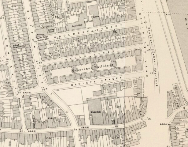
The Grosvenor Buildings was also typical of late-nineteenth-century London: a substantial housing development for London’s new working-class population, built by property developers who sensed that there were healthy profits to be made out of the urgent need for mass housing. The property developer James Hartnoll built the Grosvenor Buildings in the late 1880s. He advertised apartments in his new property in the era’s popular newspapers, such as Lloyd’s Weekly Newspaper. The advertisements promised: ‘Separate water closet, Separate Sink, with good supply of Water, Separate Copper, Separate Cooking Range, Separate Dresser … Plenty of Shelves and good Cupboards, Venetian Blind … Equal to a house all to yourself.’ One advert also carried a note from a Medical Officer of Health, which proclaimed the ‘handsome blocks of Artisans’ dwellings’ as being ‘an event worthy of record.’3
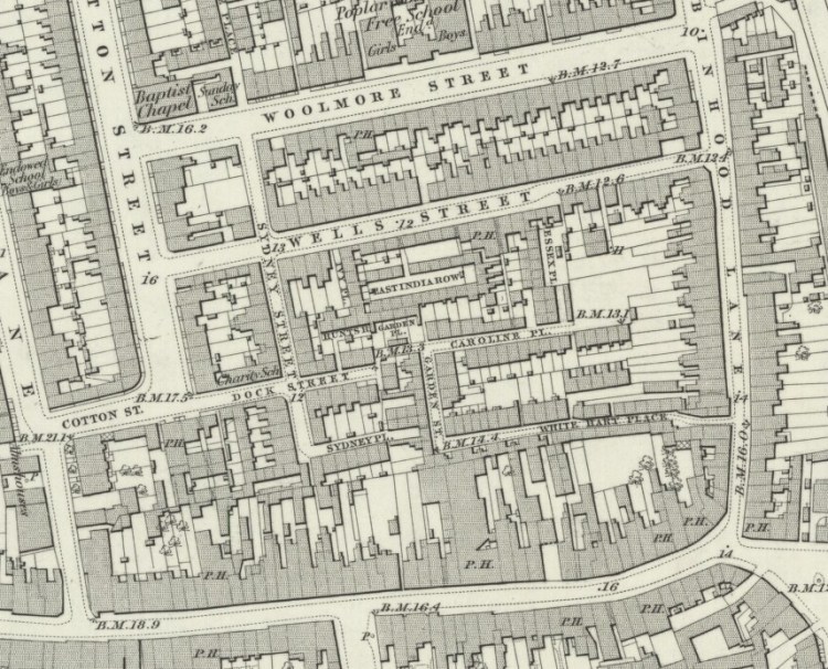
The Grosvenor Buildings replaced a labyrinthine slum of over two-hundred houses that had grown up in a haphazard fashion around Wells Street and Robin Hood Lane. Over a thousand people lived in this maze, interconnected by no less than twenty alleys, lanes and courtyards. Charles Booth surveyed the area in the 1880s. He found Poplar to be a jerry-built neighbourhood, in which buildings fell into decay with ‘startling rapidity’. Booth wrote that the air in Poplar was poor and fevers persisted because of the ‘foul rubbish’ used to level out the ground prior to settlement.4 In and around Robin Hood Lane, many houses had sunken below the level of the pavement. Sanitation facilities were scant and fresh water completely lacking. The authorities declared the neighbourhood as ‘one of the most unhealthy rookeries in Poplar’.5
Though an obvious improvement on the slums they replaced, the Grosvenor Buildings quickly gained their own notoriety. Not because they had been poorly built, but because unscrupulous landlords allowed the rooms to become overcrowded. In 1894, while thirty of the estate’s 542 flats still remained empty, the estate as a whole was already home to three-hundred more people than originally intended.6
This is borne out by my great-grandfather Jack Chipperfield’s experience. According to the 1891 census, he was living in flat no. 356 with his wife Mary and their young daughter Dorothy. Also living with them at this point in time was one of Mary’s brothers, William, and one of her sisters, Clara. The Chipperfields’ domestic situation was not unusual, and highlights another of those structural challenges faced by the transition from an agri-rural to urban-industrial society: that of extended family units being mapped onto new forms of high-density accommodation intended to accommodate what we now refer to as the nuclear family.
Overcrowding and poverty were rife in the Grosvenor Buildings. When Charles Booth, accompanied by the District Inspector of Police, Mr Carter, walked along Wells Street on 12 June 1897, he noted that ‘in the [Grosvenor] Buildings live a number of prostitutes plying for hire in the East India Dock Road’.7 It was swiftly acknowledged that, in spite of replacing slums of bad renown, the Grosvenor Buildings themselves ‘did not themselves bear an enviable reputation.’8 My great-grandparents moved out of the Grosvenor Buildings before the next census took place in 1901.
The reputation of the Grosvenor Buildings never improved. There followed a series of rent strikes in 1915 and 1939. Reports of rat-infested flats and a lack of bathrooms were widely publicised in the British press in 1963, when two-hundred tenants marched on Whitehall, demanding improvements to their living conditions.9 In 1965 the Grosvenor Buildings were purchased by the Greater London Council and subsequently demolished.
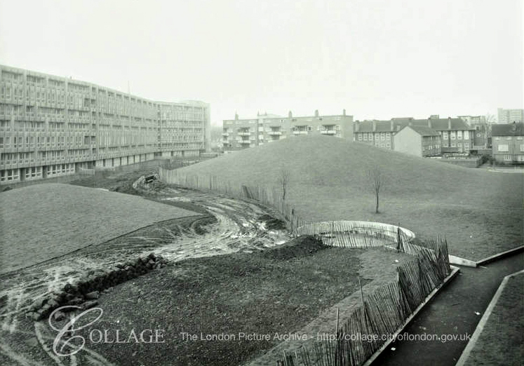
In the late sixties, construction work began on the Grosvenor Buildings’ successor, Robin Hood Gardens. The new estate was designed by architects Alison and Peter Smithson, and consisted of two long concrete blocks, one seven storeys in height, the other ten storeys. Dubbed ‘streets in the sky’, the blocks comprised a total of 214 flats. The blocks sheltered a green, ‘stress-free’ space in between, overlooked by the flats’ living rooms and bedrooms. At the centre of this quiet, open space rose a low hill – the grassed-over rubble remains of the Grosvenor Buildings.10
Forty years later, the cycle of history has started to repeat itself again. Robin Hood Gardens will in turn be replaced by another housing estate promising improved conditions for its residents. But if there’s one lesson to be learnt from the fates of the Grosvenor Buildings and Robin Hood Gardens, it is that urban designs and architectural plans are not by default the root of the problem here. It is the lack of governmental regulation and investment needed to protect tenants’ rights and adequately maintain properties.
*Banner image: Robin Hood Gardens, by Ben Scicluna (Flickr) CC BY-NC 2.0.
Footnotes
- ‘V&A acquires section of Robin Hood Gardens’ 9 November 2017. V&A Press, accessed December 19, 2017, https://www.vam.ac.uk/info/press/
- ‘Robin Hood Gardens – C20 launches campaign for funds’. Twentieth Century Society, 30 November 2008, accessed January 16, 2018, https://c20society.org.uk/press-releases/robin-hood-gardens-c20-launches-campaign-for-funds/
- , accessed December 15, 2017, http://www.bl.uk/onlinegallery/onlineex/evancoll/a/014eva000000000u06448000.html
- Charles Booth (ed.), Labour and the Life of People (London: Williams and Norgate, 1891), p.71
- The Metropolitan Board of London, quoted in “Between Poplar High Street and East India Dock Road: Bazely, Wells, Woolmore, Cotton and Ashton Streets,” in Survey of London: Volumes 43 and 44, Poplar, Blackwall and Isle of Dogs, ed. Hermione Hobhouse (London: London County Council, 1994), pp.188-199. British History Online, accessed December 19, 2017, http://www.british-history.ac.uk/survey-london/vols43-4/pp188-199
- Ibid.
- Charles Booth, ‘Walk with Mr Carter, District Inspector of Police, 12 June 1897’ Charles Booth Archive, London School of Economics, B 346, pp.14-15
- Survey of London, pp.188-199.
- ‘“Rats in flats” tenants on march’ Daily Mail, September 23, 1963.
- Alison and Peter Smithson, Ordinariness and Light: Urban Theories 1952-1960, and their Application in a Building Project 1963-1970 (London: Faber & Faber, 1970), pp.187-195
